In a world where smartphones dominate everything from communication to entertainment, it’s easy to assume they’ve made other devices obsolete. But when it comes to hiking—where navigation accuracy and battery life can be a matter of safety—the question arises: Is it still worth buying a dedicated GPS device?
While many hikers now rely on smartphone apps like AllTrails, Gaia GPS, or Komoot, dedicated GPS devices from brands like Garmin remain popular among serious adventurers. So which is truly better: the convenience of a smartphone or the rugged reliability of a GPS unit?
Let’s take a deep dive into both options and help you decide what best suits your hiking needs in 2025.
When choosing between a smartphone and a dedicated GPS device for hiking, it’s important to consider your environment, the type of hiking you do, and what safety or convenience features you need most. Here’s a deeper look at the strengths and weaknesses of both options:
Extreme Battery Endurance
Designed for prolonged use, most dedicated units like the Garmin GPSMAP 67i can last 100–180+ hours in GPS mode. This means no need to worry about recharging during multi-day treks.
Full GPS Satellite Access
Access to multiple satellite systems (GPS, GLONASS, Galileo, etc.) enables faster fixes and greater accuracy, especially in dense forests, narrow canyons, or mountainous areas where smartphones may lose signal.
Built for Harsh Conditions
Most GPS units are IPX7-rated or higher: waterproof, dustproof, and shock-resistant. This durability is essential when hiking in rain, snow, or rough terrain.
Physical Controls
Physical buttons offer better usability with gloves or in wet conditions, unlike touchscreens that become unreliable when wet or frozen.
Emergency Features
Many modern GPS devices include built-in SOS communication (via satellite) and two-way messaging, which can save lives when hiking beyond cellular range.
Dedicated Use
A GPS does one job and does it well—navigation. No distractions from social media, emails, or incoming calls.
Higher Initial Investment
Quality GPS devices typically cost between €200–€700, which might be steep for occasional hikers.
Another Device to Carry
Adds weight to your backpack, and managing multiple devices (including charging) can be inconvenient.
Learning Curve
Some interfaces, especially on high-end models, may feel less intuitive than smartphone apps. You’ll need to spend time learning how to use all features effectively.
Limited Multimedia
No ability to take high-quality photos, access weather apps, or multitask like you can on a smartphone.
Convenience & Familiarity
You’re already carrying a smartphone. With intuitive apps and a familiar touchscreen interface, there’s no learning curve for most users.
Powerful App Ecosystem
Apps like Gaia GPS, AllTrails, Locus Map, and Komoot offer advanced features: route planning, offline maps, real-time weather, trail conditions, and user reviews.
Multi-Purpose Tool
Acts as a camera, communication device, flashlight, music player, and more—all in one lightweight unit.
Cost-Effective
Many powerful GPS apps are free or available for a one-time purchase/subscription, making it a budget-friendly option for most hikers.
Online Integration
Easier to plan, share, and sync trips across devices and services like Google Drive or Strava.
❌ Cons:
Battery Drain
Continuous GPS use, especially with screen on and maps loading, drains batteries fast—sometimes in 4–6 hours. You’ll need external power banks for anything beyond a short hike.
Vulnerability to Weather and Drops
Without a rugged case, smartphones are prone to shattering, water damage, or malfunction in extreme cold or heat. A dead phone in the wild = no maps, no calls, no help.
Signal Dependency and Lag
While most modern phones can use GPS without data, many apps depend on signal to load maps, sync routes, or share location. A spotty signal can cripple navigation.
No Built-In Safety Tools
Unless paired with a satellite communicator, smartphones cannot send SOS signals without a mobile network—critical in life-threatening situations.
| Feature | Dedicated GPS Device | Smartphone with Apps |
|---|---|---|
| Battery Life | ✅ Up to 180 hours | ❌ 4–12 hours (typical) |
| GPS Accuracy | ✅ High (multi-band GNSS) | ⚠️ Varies by phone |
| Durability | ✅ Rugged & weatherproof | ❌ Needs case/protection |
| Signal Independence | ✅ Full GPS anywhere | ⚠️ May rely on cell/data |
| Navigation Features | ✅ Advanced tools | ✅ App-based features |
| Ease of Use | ⚠️ Slight learning curve | ✅ Very intuitive |
| Cost | ❌ €150–€700+ | ✅ Free–€30 (app) |
| Emergency Communication | ✅ Built-in on some models | ❌ No SOS without network |
When you’re deep in the wilderness, your navigation tool isn’t just a convenience—it’s your safety net. Here’s why battery life, durability, and accuracy should be your top priorities when choosing between a dedicated hiking GPS and a smartphone.
🔋 1. Battery Life
Why it matters:
In remote areas, there are no charging stations. Your device must last for the entire duration of your hike—especially on multi-day trips or in emergency situations.
✅ Dedicated GPS Devices:
Most run on replaceable AA batteries or have long-lasting built-in lithium batteries.
Models like the Garmin GPSMAP 67i offer up to 180 hours in tracking mode or 840 hours in expedition mode.
GPS devices consume far less power because they don’t run multiple background apps or bright displays like smartphones.
⚠️ Smartphones:
Using GPS with the screen on drains battery fast—expect 4 to 10 hours of usage on average.
Power-saving options like airplane mode help, but you’ll likely need a power bank or solar charger for longer hikes.
If your phone dies, you lose navigation, emergency contacts, and your camera.
Even with a GPS device, carry spare batteries or a compact power bank to stay safe.
🧱 2. Durability
Why it matters:
Trails can be rough—your gear should be tougher. Devices should handle rain, snow, heat, and accidental drops without skipping a beat.
✅ Dedicated GPS Devices:
Built for abuse: Most are rated IPX7 or higher, meaning they can survive being submerged in water for 30 minutes.
Shockproof and temperature-resistant, ideal for alpine conditions or humid jungles.
Designed with physical buttons, which are easier to use with gloves or wet hands than touchscreen controls.
Example: The Garmin eTrex series has a proven track record of surviving years of heavy use in rugged terrains, from the Andes to the Arctic.
❌ Smartphones:
Even rugged models like the CAT S62 Pro or Samsung Galaxy XCover require protective cases to compete with GPS units.
Touchscreens become unreliable in the rain or snow.
Internal components are vulnerable to heat, moisture, and impact. A cracked screen mid-hike can make your phone unusable.
If using a smartphone, invest in a rugged waterproof case, and store it in a ziplock or dry bag.
📡 3. GPS Accuracy and Signal Reliability
Why it matters:
Getting lost isn’t just inconvenient—it can be dangerous. Especially in fog, dense forests, or unfamiliar mountains, precise location data is critical.
✅ Dedicated GPS Devices:
Use multiple global satellite systems: GPS (USA), GLONASS (Russia), Galileo (EU), and BeiDou (China).
Many models now support multi-band GNSS, offering sub-meter accuracy, even in deep canyons or under thick tree cover.
No reliance on cell towers or internet. They get a fix directly from satellites.
Example: The Garmin inReach Mini 2 continues to track accurately in Patagonia, where cell service is nonexistent.
⚠️ Smartphones:
Most modern smartphones include A-GPS (Assisted GPS), which is partially dependent on cellular or Wi-Fi networks for faster fixes.
Offline GPS is possible, but less reliable in isolated areas or rugged terrain.
Location may “jump” or lag, especially with older devices or in airplane mode.
If using your phone, use GPS apps that support offline satellite maps and test your device’s GPS capabilities before hitting remote trails.
🧭 Summary of Key Features
Feature | Dedicated GPS Device | Smartphone with GPS App |
|---|---|---|
Battery Life | Up to 180+ hours, often replaceable batteries | 4–12 hours, needs external battery |
Durability | Waterproof, shockproof, weather-resistant | Fragile unless protected, touch-sensitive |
Accuracy | Satellite multi-band GNSS, highly reliable | A-GPS; may struggle in remote terrain |
If you’re planning serious hikes—whether that means multi-day treks, backcountry expeditions, or summit attempts—you need a GPS device that can match your ambition. Below are five of the most trusted and capable hiking GPS devices available in 2025. Each has been selected for its performance, reliability, and usefulness in extreme environments.
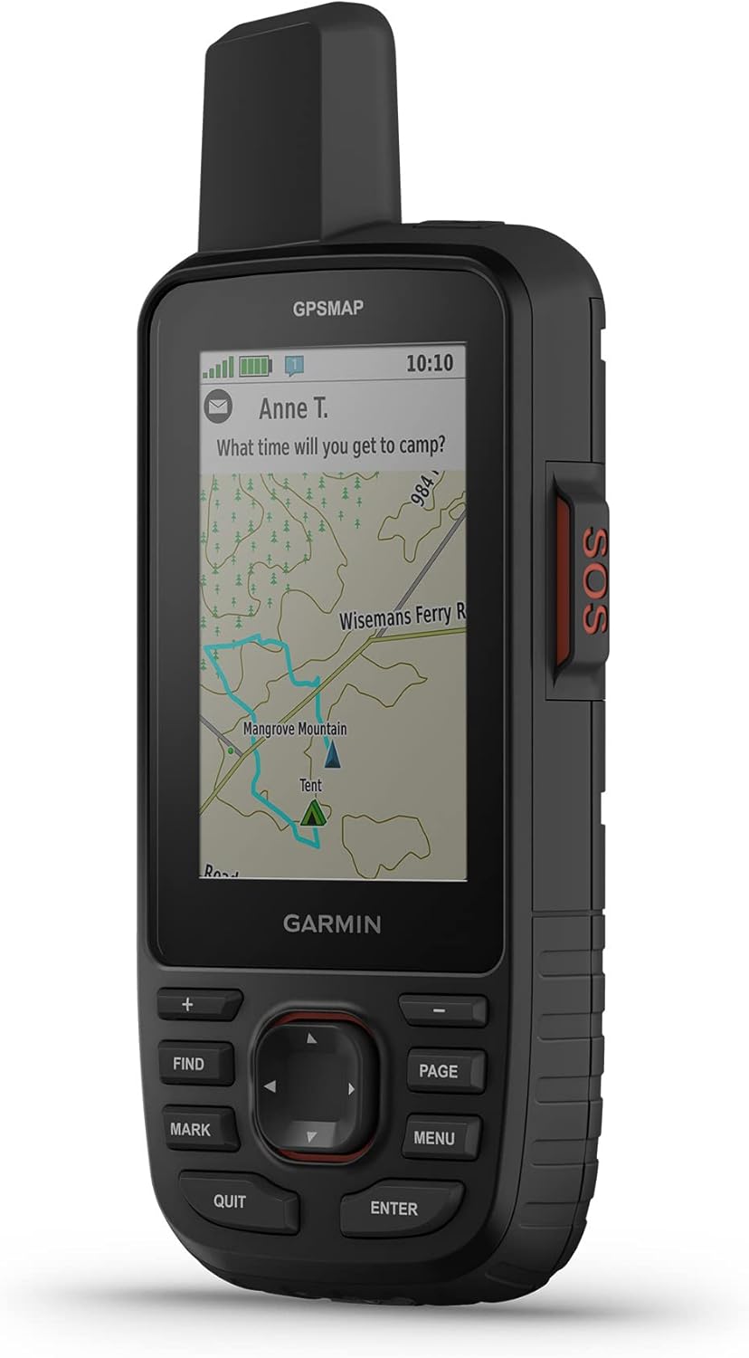
The Garmin GPSMAP 67i is often considered the gold standard for backcountry navigation, especially for those who prioritize safety and extended trips off the grid. This device combines multi-band GNSS support with Garmin’s inReach satellite communication technology, allowing users not only to navigate with incredible precision but also to send and receive messages or SOS alerts anywhere in the world. It has a rugged, handheld design with a high-resolution display that remains readable in bright sunlight. Unlike smartphones, it thrives in extreme conditions—cold alpine regions, torrential rain, or dense forests pose no challenge.
One of the GPSMAP 67i’s standout features is its astonishing battery life. In standard GPS mode, it can last for well over a week of typical use, and switching to expedition mode can stretch that to over a month. For mountaineers, thru-hikers, or those trekking into uncharted areas, it’s an excellent all-in-one device that offers navigation, tracking, communication, and safety features in a single rugged package.
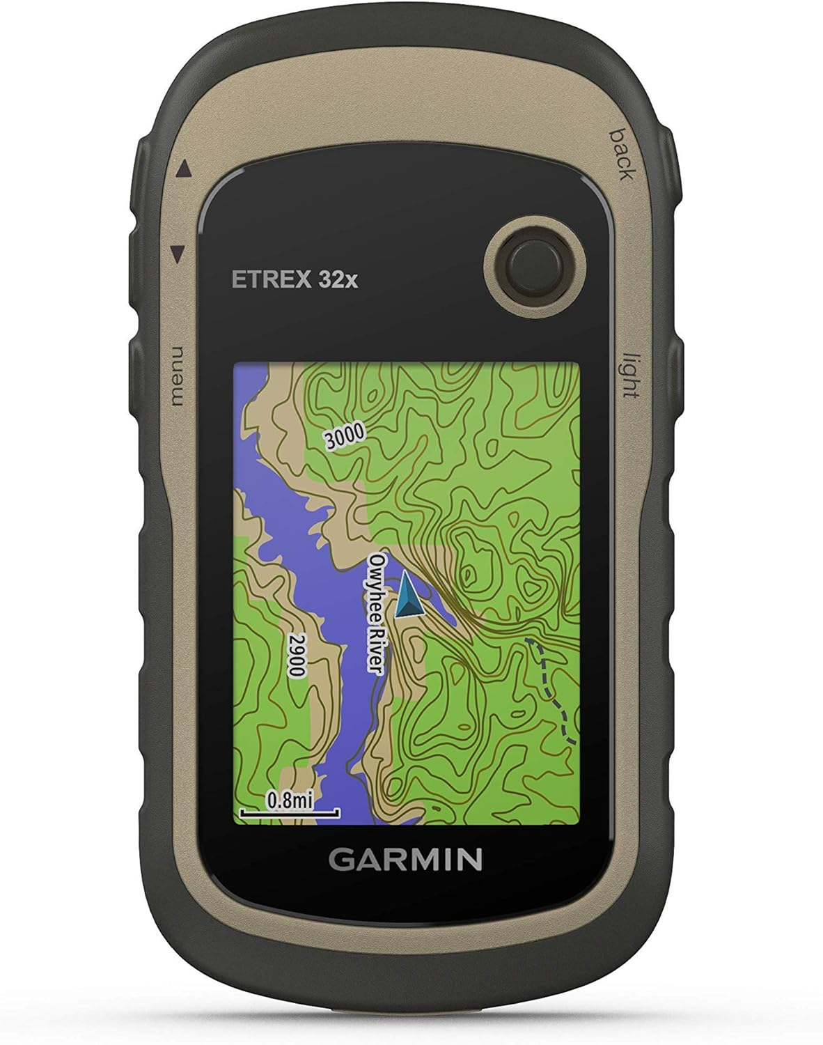
Compact and reliable, the Garmin eTrex 32x is ideal for hikers who want solid performance in a smaller, lighter package. It’s particularly popular among backpackers and minimalist adventurers who need a dependable GPS but don’t want to carry a heavy, feature-laden device. The eTrex 32x supports both GPS and GLONASS satellite systems, giving it excellent performance in challenging environments where single-system receivers might struggle—such as narrow canyons or dense tree cover.
Its physical buttons make it easy to operate with gloves or in wet conditions, and the display remains clear even in direct sunlight. The device comes with preloaded topographic maps for many regions, and users can expand the mapping capability with additional downloads or memory cards. While it doesn’t have messaging or SOS features like more advanced models, the eTrex 32x excels at providing basic, reliable navigation for hikers who prefer to keep things simple.
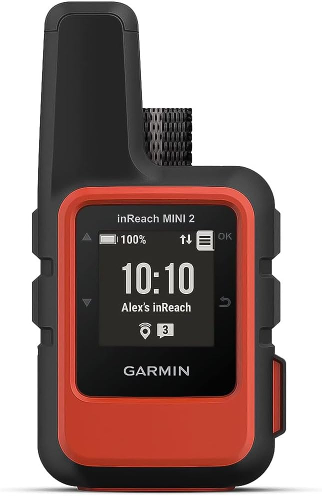
The inReach Mini 2 is a marvel of engineering: an ultra-compact satellite communicator that still manages to pack in serious GPS functionality. Though it’s best known for its global two-way messaging and SOS capabilities via the Iridium satellite network, it also functions as a standalone GPS unit with tracking, waypoint marking, and breadcrumb trail features. Its size makes it perfect for ultralight hikers, trail runners, or solo adventurers who need a lifeline without the bulk of a full handheld GPS.
While the display is small and not designed for detailed map viewing, the device pairs seamlessly with Garmin’s Explore app on your smartphone or tablet. This setup allows you to plan routes, download offline maps, and monitor your trip in more detail using your mobile device, all while relying on the Mini 2 as your communication and positioning hub. It’s especially valuable in emergency situations, where being able to send an SOS message from anywhere in the world can be life-saving.
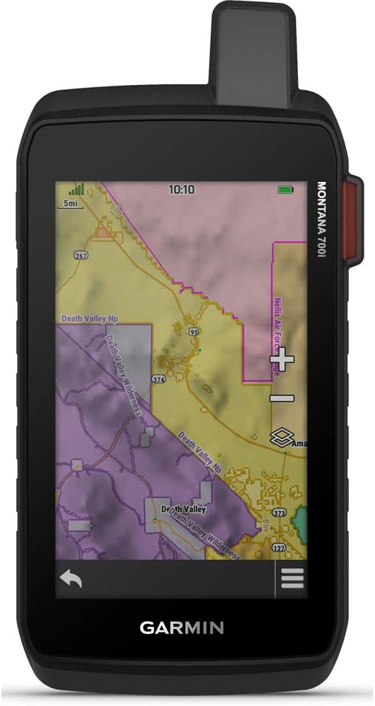
The Garmin Montana 700i is designed for serious outdoor expeditions and those who need a device that’s part GPS, part tablet. It features a large, glove-friendly touchscreen and supports full topographic and street navigation, making it ideal for both hiking and overlanding. Its robust case and waterproofing make it well-suited to rugged environments, and it’s commonly used in activities ranging from long-distance hiking to off-road vehicle expeditions.
One of the key advantages of the Montana 700i is its versatility. In addition to hiking-specific features like route tracking, altimeter, and barometric pressure monitoring, it includes full inReach satellite messaging capabilities and the ability to sync with multiple devices via Bluetooth or Wi-Fi. Its large screen offers a much better visual experience than smaller handhelds, which is particularly useful for navigating complex trail systems or scanning large terrain sections during planning. While it’s heavier and more expensive than other models, the Montana 700i replaces the need for separate navigation and communication tools, making it a compelling all-in-one solution.
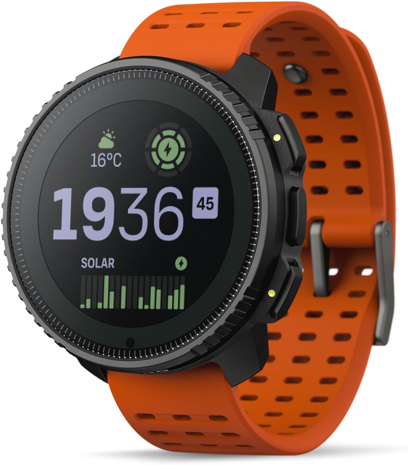
Although Suunto is traditionally known for its GPS watches, the Suunto Vertical is a standout device that bridges the gap between smartwatch convenience and serious outdoor utility. Designed with mountaineers, trail runners, and long-distance hikers in mind, it features dual-frequency GNSS, offline topographic maps, and a highly accurate barometric altimeter—all packed into a wristwatch format.
One of the Vertical’s strongest advantages is its battery life. When using dual-band GNSS for high accuracy, it still lasts for over 80 hours. In lower-precision tracking modes, it can last well beyond that—making it one of the longest-lasting GPS watches on the market. It also includes solar charging in the premium models, further extending its usability during extended treks. The Vertical syncs with the Suunto app for detailed route planning and analysis, making it an excellent choice for those who prefer to wear their navigation tool rather than carry it.
Each of these devices serves a different type of adventurer, from the ultralight minimalist to the overprepared expedition leader. Whether you prioritize battery life, communication features, ruggedness, or compact design, there’s a GPS model tailored to your style of hiking. In all cases, these tools do more than just show you where you are—they enhance safety, confidence, and enjoyment on the trail.
When you’re out in nature, your navigation device is your lifeline. Whether you’re using a dedicated GPS unit or a smartphone with hiking apps, conserving battery life is crucial, especially on multi-day hikes or remote trails where power outlets are non-existent. Poor battery planning can turn an exciting adventure into a dangerous situation. Let’s dive into the most effective strategies to extend your device’s battery life and ensure you’re never caught with a dead screen in the middle of nowhere.
Smartphones are powerful but energy-hungry. GPS tracking, screen brightness, background apps, and network searches can quickly drain your battery. Here’s how to stretch your phone’s stamina on the trail:
Switching to airplane mode disables mobile, Wi-Fi, and Bluetooth connections—massive battery savers. But most phones still allow GPS functionality in airplane mode, so you can continue navigating using offline maps.
Pro Tip: Test this before your hike to ensure your app supports offline GPS.
Apps like Gaia GPS, Komoot, and Locus Map allow you to download entire regions in advance. This eliminates the need to load map tiles using mobile data, saving energy and avoiding connectivity issues in remote areas.
Bonus: Offline maps often load faster and work even when your phone has no signal.
Display power consumption is one of the biggest battery killers. Lowering your screen brightness and using dark mode (available in most modern Android and iOS apps) can significantly extend battery life.
Close all non-essential apps and turn off push notifications before you start your hike. Many apps continue running in the background, using power even when not in use.
Settings to Check:
Turn off auto-sync
Disable app refresh in the background
Disable location tracking for unused apps
Enable your phone’s built-in battery saver or low power mode. This limits performance and background activity, perfect for long hikes where you need your phone to last all day or longer.
Batteries drain faster in cold environments. Keep your smartphone in an inside pocket close to your body to maintain battery temperature, or wrap it in a beanie or sock when not in use.
Carry a reliable power bank (10,000 to 20,000 mAh recommended) with fast-charging capability. This can recharge your phone 2–5 times depending on your model, giving you several days of navigation and camera use.
GPS units are inherently more power-efficient than smartphones, but even they benefit from smart energy management. Here’s how to get the most out of your GPS device:
Many Garmin models offer special modes that reduce GPS ping frequency or disable non-essential features. These modes can extend battery life from dozens to hundreds of hours.
Example: The Garmin GPSMAP 67i lasts up to 840 hours in expedition mode.
Disable features like Bluetooth, ANT+, and Wi-Fi if you don’t need them. These drain the battery over time, even when not actively in use.
Unlike smartphones, many GPS devices don’t need constant screen time. Set the display to turn off after a short period of inactivity. Use physical buttons to navigate without waking the screen when possible.
Some GPS models (like the eTrex series) use standard AA batteries, allowing you to carry lightweight backups. For models with internal batteries, bring a portable USB charger compatible with your unit.
Note: If your GPS uses lithium batteries, choose high-quality rechargeable ones like Eneloop Pro for better performance in cold temperatures.
If you’re on a familiar route or resting at camp, consider pausing or turning off track recording temporarily to save power.
If your GPS supports accessories like external antennas or messaging functions, use them only when needed. Satellite communication features, in particular, consume significant battery when active.
Test your setup before a big trip. Learn how long your device lasts with GPS enabled under real conditions so you can plan charging intervals.
Keep cords organized and dry. Carry a zippered pouch for cables, charging blocks, and battery packs to protect from weather and tangling.
Label your gear. Avoid mix-ups in group hikes by marking your power bank or charger with your initials or bright tape.
By applying these strategies, you can extend your device’s life well beyond a single day, giving you more peace of mind and flexibility on the trail. Whether you’re navigating a high-altitude pass, descending into a forest valley, or camping deep in the backcountry, conserving battery power means staying informed, oriented, and—most importantly—safe.
After weighing the pros and cons, comparing key features, and reviewing top-rated devices, one thing is clear: both smartphones and dedicated GPS units have their place in modern hiking, but the right choice depends on your hiking style, environment, and safety priorities.
For casual hikers, day-trippers, or those sticking to well-marked trails and areas with decent cell coverage, a smartphone loaded with reliable offline maps can be a practical and budget-friendly option. Modern hiking apps offer excellent functionality, and with proper battery management and preparation, smartphones can serve as effective navigation tools for short adventures.
However, if you’re a serious hiker, backcountry explorer, mountaineer, or someone who frequently ventures off-grid, a dedicated hiking GPS is more than just helpful—it’s essential. These devices offer significantly better battery life, satellite accuracy, weather resistance, and safety features. In critical moments, such as whiteouts, trail confusion, or emergencies, the durability and reliability of a dedicated GPS can literally be a lifesaver.
Additionally, GPS units with satellite messaging capabilities (like the Garmin inReach series) offer an invaluable lifeline when things go wrong. No mobile phone signal? No problem—you can still send your coordinates, communicate with emergency services, and stay in touch with loved ones.
That said, many experienced hikers now carry both: a smartphone for convenience, photos, and app-based planning, and a GPS device as a rugged, reliable backup and safety tool. This hybrid setup offers the best of both worlds—ease of use with your phone, and total peace of mind with your GPS.
Use a smartphone for short, local hikes with good preparation and battery-saving tools.
Invest in a dedicated GPS device if you’re hiking in remote, rugged, or unpredictable environments, or if your life may one day depend on staying found.
For maximum safety and versatility, combine both tools—and always carry a power source, downloaded maps, and a backup plan.
Your navigation device isn’t just a gadget—it’s part of your survival kit. Choose wisely, hike responsibly, and enjoy the journey with confidence and clarity.
| Cookie | Duration | Description |
|---|---|---|
| cookielawinfo-checbox-analytics | 11 months | This cookie is set by GDPR Cookie Consent plugin. The cookie is used to store the user consent for the cookies in the category "Analytics". |
| cookielawinfo-checbox-functional | 11 months | The cookie is set by GDPR cookie consent to record the user consent for the cookies in the category "Functional". |
| cookielawinfo-checbox-others | 11 months | This cookie is set by GDPR Cookie Consent plugin. The cookie is used to store the user consent for the cookies in the category "Other. |
| cookielawinfo-checkbox-necessary | 11 months | This cookie is set by GDPR Cookie Consent plugin. The cookies is used to store the user consent for the cookies in the category "Necessary". |
| cookielawinfo-checkbox-performance | 11 months | This cookie is set by GDPR Cookie Consent plugin. The cookie is used to store the user consent for the cookies in the category "Performance". |
| viewed_cookie_policy | 11 months | The cookie is set by the GDPR Cookie Consent plugin and is used to store whether or not user has consented to the use of cookies. It does not store any personal data. |